CHILE - NORTHERN PATAGONIA 7 days
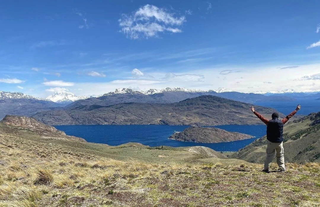
This itinerary visits the spectacular Carretera Austral Highway (Route 7), Laguna San Rafael National Park, the isolated unique geological formation of the Marble Caves near the town of Puerto Rio Tranquilo and the stunning Patagonia National Park.
Remote and far from everything, Northern Patagonia is a vast area filled with glaciers, mountains, fjords and turquoise blue color rivers. It is one of the world’s most beautiful destinations and attracts travelers with an eagerness for adventure. It is accessible via the Carretera Austral (Route 7) - one of the most scenic drives in the world. Plus, it is a gateway to a trekkers' paradise at various national parks.
Northern Patagonia is one of the most remote places on Planet Earth. Volcanoes, mountains and glaciers create one of the most beautiful natural sites Chile has to offer.
Tips:
Patagonia is the perfect area for a self-drive adventure. This remote region is generally very safe for tourists and with normal safety precautions, you should have no problems navigating the region. Renting a car and exploring is the best option.
Overview of Chile’s National Parks. <Video>
PETROL Warning: You should take note of the mileage and how much petrol you use as this does become an important factor has you drive in this region.
There are a very limited number of petrol stations. You should be aware at which locations you can find gasoline.
Patagonia Travel Guide: Moon Patagonia and Lonely Planet Chile.
Weather conditions can change very quickly in this region. (see below our data)
FAQ’s about Patagonia’s National Parks.
Download the All-Trails app on your smartphone. Essential for any trek in Chile.
DAY 1
Arrive at Balmaceda airport and transfer to your hotel in Coyhaique.
Latam Airlines and Sky Airlines serve Balmaceda airport.
Coyhaique sits right in the middle of the Carretera Austral (Route 7), and it is a good base to start your self-drive adventure. The Carretera Austral is one of the most famous 'road trip' roads in the world, connecting the remote areas in southern Chile and passes through breathtaking scenery.
Drive south from Coyhaique and you'll head into the spectacular Patagonia region. Much of the route is unpaved, so prepare for a bumpy drive.
Overnight: Coyhaique
Suggested Hotels: Diego de Almagro Coyhaique, Calafate Lodge Patagonia and Calafate Apart Hotel.
Distance:
Balmaceda airport ---> Coyhaique. 1 hour.
DAY 2
Depart to Puerto Rio Tranquilo.
The 6-hour drive takes you through some of the most spectacular scenery on the planet. The road is part of the the famous Cerretera Austral highway (Route 7). This highway is characterized by thick forests, fjords, glaciers and steep mountains. There are countless breathtaking photo stops along the way. <Map+tourist information locations>
Driving ALERT: Routine road work can cause sections of the Cerretera Austral highway to be closed, normally between 1 pm and 5 pm during the weekday. This information is best found by consulting the tourism office of the town you’re in or asking your tour operator and then planning accordingly.
List of tour operators for activities in area.
Overnight: Puerto Rio Tranquilo (3 nights)
Distance:
Coyhaique ---> Puerto Rio Tranquilo, 6 hrs.
DAY 3
Full day guided excursion to San Rafael Glacier.
The San Rafael Glacier is one of the major glaciers of the Northern Patagonian Ice Field. It is part of the Laguna San Rafael National Park.
This excursion is available from September to late April.
How to reach the San Rafael Glacier:
From Puerto Río Tranquilo— you can self-drive or be transported by your tour operator to Bahía Exploradores (Road X-728), which is the starting point of the glacier tour. The advantage of self-drive is that on the return you can stop on the Bahia for great photos and views.
The gravel road from Puerto Rio Tranquilo is known as the Bahia Exploradores Road and is 90 km (52 mi) in distance. <Map>
ALLOW 2-2.5 hours to reach the passenger sailing point. Sailing time is ~ 9:30 AM.
Passengers board a vessel and sail to Laguna San Rafael to see the glacier.
Be AWARE - it is common for the glacier tour to be cancelled due to bad weather conditions.
Your payment will be refunded.
Overnight: Puerto Rio Tranquilo
DAY 4
Marble Caves excursion:
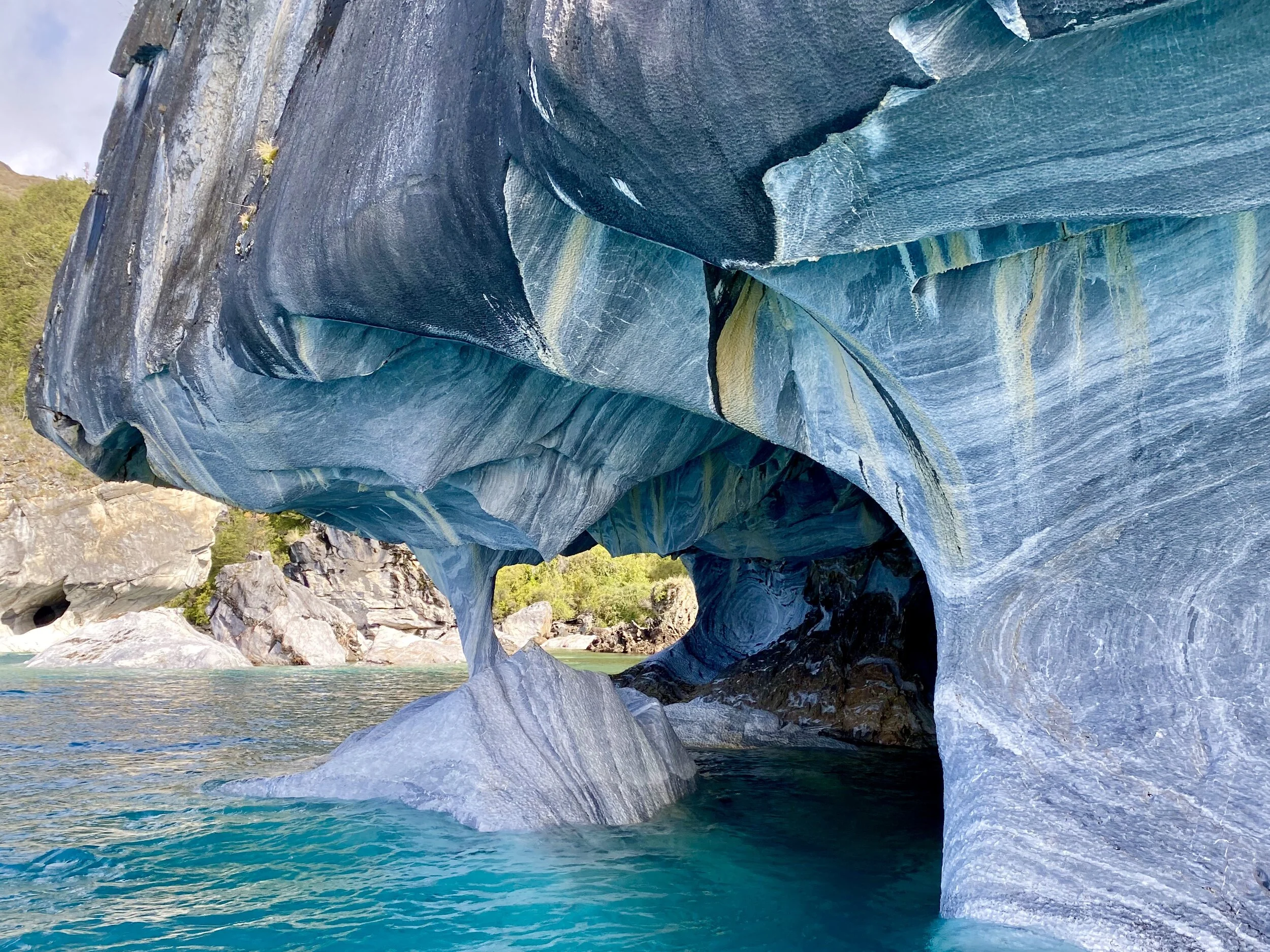
One of the most isolated natural treasures on the planet, the Marble Caves (Capillas de Mármol) are a series of sculpted caves in General Carrera Lake.
The caves reflect sea foam greens, sapphire blues, and frosty grays onto rounded rock walls smoothed out from centuries of waves crashing against them.
The best time to visit the Caves is between mid-September through February.
The only way to reach the Marble Caves is by a 30-minute boat ride from the town of Puerto Rio Tranquilo.
You generally spend one (1) hour there. Be aware that the boat ride can be rough with high waves. Seasick is possible.
Kayaking at the Marble caves can be arranged by your tour operator.
Be AWARE - it is common for the cave tour to be cancelled due to bad weather conditions. The Chile coast guard decides each morning. If cancelled, your prepayment will be refunded.
In afternoon, drive toward Patagonia National Park. Stops along the way include:
Puerto Guadal - a small town on the shores of Lake General Carrera with postcard picture setting.
La Confluencia trail - A favorite spot for visitors, the confluence of the Baker and Chacabuco Rivers, lies very close to the park’s western entrance. Drive on the Carretera Austral (Rt. 7), find a spot to park, and head down the trail. The walk down is approximately 20 minutes.
Trail details: 1 hour, 3 km (2 miles) round trip, Difficulty: easy.
Overnight: Patagonia Park area. (3 nights)
-Valle Chacabuco, highly expensive, recommended if your wallet can handle it.
Distance: Puerto Rio Tranquilo--> Patagonia Park. 2 hrs.
DAYS 5 and 6
Explore Patagonia National Park.
Patagonia Park is one of the most wild, untamed parks with world-class scenery.
The best place for information is at the Valle Chacabuco Visitor Center about a 30-minute drive into the park. This is the main area of the Park.
You can drive through the park for amazing views if hiking is not an option.
The park has one main road – the scenic Highway X-83 that leads through the park all the way up to the Argentina border on the east.
The drive through the park is beautiful. The 1.5-hour long drive (each way) exposes visitors to the majesty beauty.
Compared to city trips you need to pack more functional clothes due to the weather conditions which can change very quickly in this region. You should invest into some good outdoor clothes which are comfortable but also easy to handle.
This video will take you through the Aviles Loop.
Hiking suggestions:
All Trails-essential hiking app.
The Avilés Trail - one of the most remote and dramatic trails.
After breakfast, drive up the valley to the Casa de Piedra campground (a.k.a. historic Stone House) to begin this 16-km (10-mi.) loop trail up the Avilés Valley.
Walk up the valley to a dramatic hanging footbridge—100 feet long and 100 feet high over the Aviles River, cross the river via the hanging footbridge, and return on the other side leading to the end of the hike.
Directions- from lodge to Stone House to footbridge.
Difficulty: moderate, 5-6-hour duration.
Mirador Douglas Tompkins Trail: from the Alto Valle Campground it is a 14 km.(8.4 mile) lightly trafficked out and back trail. —Awesome view at end of trail.
<Location>
Difficulty: moderate, 4-5-hour duration, elevation gain of 410m (1,348 ft.)
DAY 7
Depart Patagonia Park for Balmaceda airport for flight home or another Chile/South America destination.
Latam Airlines and Sky Airlines fly out of Balmaceda airport.
Distance: Patagonia Park —-> Balmaceda airport. 6 hours.
Average cost:
(EXCLUDING AIRFARE)
$$$ USD for two (2) people.
Budget: $2,600
Moderate: $3,300
Luxury: $4,500 +
Climate Guide:
The weather in this region is both rainy maritime (in the coastal zone and fjords) and cool and more sunshine near Patagonia Park. It rains all year round, even in summer.
The months May thru August have a higher chance of precipitation.
The warmest months are December through February.
The coolest months are June through August.
Best time to visit is mid-November thru March.
Source: wikipediaNo copyright infringement is intended on this website by travelwildnow.com


